Building Your Expeditionary Skill Stack

Introduction

Scott Adams popularized the idea of a skill (aka talent) stack in his book “How to Fail at Everything and Still Win Big.” It’s hard to become the very best at one thing. Very few people get into the NBA, NFL, or PGA tour. But it’s possible to combine a pretty good golf game, conversation skills, and knowledge of persuasion and psychology to launch a successful sales career. Adams could barely draw and had no idea how to actually color his cartoons when he began his career as a cartoonist. He argued that a willingness to take risks and an inability to be embarrassed by having your mistakes revealed in public, combined with solid (but not great) abilities in several skills that work well together, goes a very long way towards success.

Scott Adams with Dilbert.

Expeditionary Skill Stacks

Can the same idea be applied to expedition success? The Oxford dictionary defined an expedition as follows:

A journey undertaken by a group of men with a particular purpose, especially that of exploration, research, or war.

Oxford English Dictionary

So expedition success can be measured as newly discovered lands, important scientific discoveries, or military victory.

Vasco De Gama’s First Voyage to India.

But what if we limit our focus to light expeditions, short journeys that let us venture into pristine, beautiful, wilderness spaces? What travel skills get us there, keep us (mostly) comfortable and well fed along the way, and get us safely back?

Can we build an expeditionary skill stack that might not get us to the top of Mount Everest, but does get us to exquisitely beautiful and private spaces that we can briefly own?

Saint Croix River near Grantsburg, Wisconsin.

The answer is yes. Consider the best expeditionary YouTubers: what do they have in common? They combine multiple skills to get them to remote wilderness spaces most people could not possibly reach.

RoKKiT KiT: Australian Catch and Cook

RoKKiT KiT combines small boat skills; an understanding of local weather, navigation, and islands; and fishing/spearing plus cooking skills to execute multi-day trips to deserted barrier islands in Australia. RoKKiT KiT also records his trips via GoPro and then posts the edited video to his YouTube channel. As of May 2021, his relaxed, engaging, you-are-there dialogue and beautiful locales have led to 343,000 subscribers.

RoKKiT KiT on a spearing mission.

The Baird Brothers: Canadian Wilderness Experts

Similarly, Jim Baird combines whitewater canoeing, bushcraft (including camping, cooking, and survival skills), and videography and editing to create and record his unique journeys in Canada’s wild North country. His brother Ted Baird is also highly accomplished in bushcraft and wilderness travel and has his own YouTube channel.

Jim Baird.

A Latter Day Viking Sailor

Expeditionary sailors like Erik Aandrea bring core sailing skills but up their game in navigation, heavy weather training, automation, and safety to achieve extraordinary sailing journeys within modest means. Erik has sailed the North Sea during winter numerous times, and recently completed a circumnavigation of the Norwegian Sea.

Building Your Own Expeditionary Skill Stack

Here’s an introduction to how to evaluate the best skills for expeditionary travel. First, you need a travel mode. Sailing, canoeing, boating, hiking, and climbing are excellent choices. Sailing in particular gives you tremendous mobility in open water without the need to constantly re-fuel (assuming you can wait out the slow or no wind days). Canoeing provides excellent flexibility including the ability to traverse lakes, rivers, and short stretches of land (known as portages). Canoes can also traverse highly technical whitewater rapids while carrying a ton of gear. And with canoes, you can always portage around falls and rapids to difficult to cross.

Whitewater canoeing.

Once you’ve chose a travel mode, you need to learn basic camping skills. How to set up a tent and tarp for shelter, how to choose the right location for camp, cooking meals, avoiding bear encounters, getting water, lighting a fire, and more. Strong camping skills allows you extended stays and multiple day trips to remote spaces. The basics are relatively easy to learn, and the quality of camping gear in general has increased exponentially in the last 3 or 4 decades.

You Can Travel, Camp, and Cook. What’s Next?

Now you can move about in the wilderness and stay for extended periods of time via basic camping and cooking skills. What’s the next skill you should considering adding to your stack?

The next most important skill is judgement based on experience. My advice is to do multiple trips that feel comfortable to you based on your skills. This gives you a chance to experience adverse conditions, including weather, bugs, and gear failures, under controlled conditions. As your experience grows, you can start increasing the length (number of days) of your trips. You can go to more remote places and push the envelope on the level of whitewater rapids while canoeing or storm levels while sailing. Do this gradually and don’t get cocky, but be willing to push the envelope somewhat as you gain experience.

Food and Aesthetics

Once you’ve built up experience and can routinely travel where most people cannot, what’s next? My suggestion is to learn photography and videography. Modern GoPro cameras and drones are inexpensive and when combined with simple video editing tools the allow you to create high-quality videos of your trips that you can share with friends and family on social media.

The possibilities with today’s miniature portable cameras like GoPro are endless.

As you gain more experience cooking outdoors, you can build up your repertoire of possible meals. Portable refrigeration is becoming lighter and more mobile so that for short, 3 to 4 day trips, you can cook almost as you do at home with similar ingredients. Beyond 4 to 5 days, you need to dehydrate meat and other perishables to reduce weight and increase wilderness “shelf” life. For short trips, grilling is ideal because it is quick, can leverage campfires, and results in fewer dishes to clean up afterwards.

Outdoor grilling can create awesome meals in the wilderness.

Conclusion

An expeditionary skill stack is a force multiplier. You can go farther than 90% of the sailors, canoeists, and backpackers who strictly focus on their own specialty. Adding more skills to help you safely navigate and traverse remote wilderness areas means you get more solitude and can experience nature’s beauty without the noise, ugliness, and distractions of modernity.

To learn more about light expeditions and expeditionary travel, here are some previous blog posts you might find useful:

Steve Backshall’s Expedition Best Practices

Steve Backshall’s Expedition Series on public television chronicles a series of firsts he and his expedition teams achieved in a single year. Ten distinct expeditions scattered around the planet were executed, varying from mountain climbing in Greenland to whitewater kayaking in Bhutan. Backshall shares this writer’s view that there are secrets to be found and firsts to be achieved today, all over the world. The only thing preventing this is a lack of imagination, curiosity, skills and courage.

Steve Backshall.

Although my writing has focused on light expeditions done at a smaller scale (in time, resources, and expertise required) than Backshall’s more traditional expeditions, the principles and best practices are the same. Team cohesion, training, planning for the worst case, and other expedition principles are important for any expedition.

Backshall’s formula is straightforward: he does the research to find unexplored locations and then puts together a team and plan to explore and discover. His expedition best practices are impeccable, no surprise given his deep experience with expeditionary travel. In this essay, I want to explain and explore these best practices so that you can leverage them on your own trips.

Backshall’s Expeditionary Skill Stack

Scott Adam’s defined a skill (or talent) stack as a “set of skills or talents that work well together.” The idea is that to become extraordinary, you need to either be extraordinary at one thing (this is hard) or be in the top 25% in two or more skills. Adams leveraged his skill at both writing and drawing to become a successful cartoonist. Similarly, Backshall combines multiple expeditionary skills, including climbing, hiking through harsh environments like jungles and deserts, camping in any environment, whitewater kayaking, know-how on how to find secret locations never explored, logistics, safety, and imagination to create extraordinary expeditions that leverage these combined skills.

Backshall’s Best Practices

Match Team Expertise and Chemistry to the Challenges Ahead

Backshall pays very careful attention to his team’s skill sets so that he his team members cover all skills required for a particular journey. Safety is his number one concern while pushing the exploration envelope. Backshall hired Aldo Cane, a former Royal Marine, as his ropes expert and lead on trip safety and handling emergencies. For each trip, Backshall found both experienced locals and the best-in-class experts to bring together global excellence with local expertise. Local naturalists, climbers, kayakers, and wildlife experts seamlessly worked with their counterparts brought in from across the globe to achieve multiple firsts, including the transit of two whitewater rivers that had never been kayaked before, multiple new cave discoveries, and two first ascents.

Train Under Conditions Similar to the Expedition

Backshall trains his teams under more controlled conditions that what he anticipates encountering in the field. He uses the world’s best and most experienced talent for the critical skills required in climbing, kayaking, cave diving, and jungle travel.

Anticipate the Worst Case and Possible Black Swans and Have a Plan for Them

Backshall works hard to imagine worst case scenarios that could occur at all stages of his complex expeditions. But given the remoteness and risks inherent in certain exploration activities like cave diving or running whitewater rapids in jungles, there is really no way to make a rescue from outside the group happen. It’s up to the team to manage safety every step of the way and be able to get themselves out of a dangerous scenario on their own.

Embrace Your Inner Child

Backshall, a naturalist, finds an interesting and rare animal, plant, or archeological artifact on nearly every expedition. The childlike pleasure he gets and shares from this experience is what drives the best explorers forward.

Leaders Drive Optimistic, Confident Energy Through Their Teams

Optimism comes from hope. Hope comes from confidence and experience. Some leaders are able to project optimism based on confidence and experience nearly effortlessly, and Backshall is one of them. He continually warns his team about potential dangers while always having a plan to deal with them.

Expeditionary leaders like Marine general Lewis Puller and British explorer Ernest Shackleton had the same gift. The confidence and optimism was infused into their teams helping them gain success in their expeditions in both war and discovery.

The Best Expeditionary YouTubers

I don’t watch television anymore and I only occasionally watch Amazon Prime (Amazon’s answer to Netflix). Instead, my eyeballs spend most of their video screen time on YouTube. There is a wide variety of useful educational content and quality documentaries.

A particular group of YouTuber’s combine expeditionary skills and passion with a reasonable budget to create some truly epic mini-documentaries. I’ve argued before that short trips can behave like mini, or light, expeditions with the right mindset and planning. The following list shows you people who are living this dream during their weekends and beyond.

Erik Aandrea

Erik Aandrea’s sailing channel is called “No Bullshit Just Sailing” or NBJS. He means it. There are no sand beaches, pina coladas, or girls in bathing suits. Just lots of footage of one of the best solo sailors on the planet right now. He sails the North Sea and especially the waters near his home in Haugesand, Norway. Erik’s Contessa 35 is a classic small sailing vessel renowned for its stability in heavy seas. Erik has taken her across the North Sea numerous times, winter included, visiting the Shetland Islands, Faroe Islands, Iceland, and islands in the Norwegian Sea.

‘Fear is only produced by the lack of knowledge, or not knowing. To get knowledge you will have to face your fear. When you face your fear, you get knowledge, and you can feel, see, and hear what you fear. At this point, the fear disappears, because you know what it is.”

Erik Aandrea, solo Norwegian sailor, right before entering, and surviving, a Force 10 storm with 20+ foot seas.

His most popular video, Encountering Storm Force 10, shows how he planned and executed a short, 7 nautical mile trip in a Force 10 storm (winds from 55-63 mph and waves 15 to 25 feet high). He started from Rovaer Island and rode the big following sea into Haugesund, coming very close to death when he got too close to a shoal. As in all of his videos, there are many outstanding video sequences and photos taken from his drone, from GoPro’s installed on his boat, and hand-held cameras.

Expeditionary YouTubers

Brad and Leah Jennings

Brad and Leah Jennings canoe eastern Canada, focusing on the waters near their home in central Ontario. Brad and Leah specialize in finding lost canoe routes that are rarely used in modern times. Like Erik Aandrea, the Jenning’s video’s are shot and edited to a very high standard, with narration and structure plus great cinematography. Since I sail and travel Lake Superior often, their 10-day Lake Superior trip video, shot as they traveled the remote northeast coast, is my favorite and is also their most popular.

Jim and Ted Baird

Jim and Ted Baird are brothers living in western Ontario who canoe the wilderness all over Canada, in their local Ontario waters, the Artic, Yukon, and Quebec. Their video style is different than the Jenning’s. They give you a more full, immersive experience in every aspect of their trips. This means they show tent setup, fire-making, cooking, cleaning, camp breakdown, and more. You get the feeling you are along for the ride rather than an observer. And Jim in particular brings you along on both the ups and downs of the trip. RoKKiT KiT has the same immersive style.

RoKKiT KiT

Our final expeditionary YouTuber, RoKKiT KiT, combines solo boating and fishing (including spearfishing) around remote barrier islands near his home in Australia. He ditches formal narration and video structure and like the Baird’s, gives you a full, immersive experience in his expeditions. A classic trip for RK is a solo trip to a beautiful deserted island in his boat where he can spearfish and fish. He shows how he catches, cleans and cooks his catch. He often travels without food, planning on living off whatever he catches on his short 1-3 day trips. Of the 5 YouTuber’s we’ve presented, he has the largest following at 335,000 subscribes. The beauty and isolation he presents, along with his fun, relaxed style drove many people trapped inside during these COVID times to his channel.

How I Got To Heaven in a Sea Kayak

A View of Heaven

What does Heaven really look like? I was about to find out as I pushed my kayak from shore. I needed to cross 6 miles of big water with strong wind blowing to get to a bay my sailor friends had described as “Heaven”. Read on and you can find out if I made it and what heaven really looks like.

In previous posts I’ve described several boat camping trips on Lake Sakakawea and a sea kayak trip down the Missouri River. Here I describe crossing Lake Sakakawea in a sea kayak on an overnight trip. My goals was to connect with sailor friends at a place they told me was Heaven.

My kayak.

The Trip Plan for Lake Sakakawea

I had done a few short day trips in my sea kayak on Lake Sakakawea to help build up more big water experience. Lake Sakakawea stretches 180 miles from the dam near Pick City in central North Dakota to Williston, on the border with Montana. The lake is the second largest reservoir by surface area in the US after Lake Oahe and it averages between 3-4 miles in width. It has 1320 miles of shoreline. That’s longer than California’s coastline. This article in the New York Times provides excellent descriptions of the lake and its shoreline.

My goals this trip were to do my first overnight camping trip in the sea kayak, and do an open water crossing where I wasn’t just hugging the shoreline as I traveled. My reward was a the chance to stay in one of the prettiest bays on the lake while connecting with my good friends who had sailed there ahead of me.

Heading Into the Open Water

The trip occurred over a weekend in June 2015. I traveled to Indian Hills resort and boat landing on the north side of the lake, about 30 miles due south of Parshall, North Dakota. My destination was on the south shore, roughly 7 miles southeast from the entrance to Good Bear Bay, where Indian Hills resides.

And this is where things got interesting. At this point my sea kayaking experience was very limited. Large waves in open water were new to me. In fact, I had abandoned several previous attempts to connect with the sailors because it involved 8 to 10 miles of sea kayaking over open water against a big wind. But today, as I worked my way out of Good Bear Bay to the big lake, I had decided no matter what, I was going to cross the lake.

The shoreline on Good Bear Bay where I started the journey across the lake.

On my way to the open lake a peninsula on the edge of the big water was perfect for lunch. The wind to that point had been light, about 5-7 knots, but it was gradually increasing to 12-15 knots from the west. The waves were building to 2 to 3 feet rapidly across a fetch (stretch) of 10+ miles. Should I go, or not?

Decision Time and the Margin of Safety

If the wind continued to increase, the waves would get even bigger. But the forecast was for winds around 15 knots, which I was seeing. Sailors use the Beaufort Scale to gauge wind speed from sea state and conditions ashore. But wind forecasts are often inaccurate, and the wind speed could increase. Going downwind and warm water (meaning I could swim for it for hours if necessary) reduced the risk. If I ended up in the water I would have to get back in and bail out the kayak. My VHF marine radio could be used to contact boaters and the first responder station in Twin Buttes if things went south. A high quality PFD and equipment to get me back in the boat increased the margin for error.

There were literally thousands of these spiders on the shoreline.

Pushing off from shore and within a few minutes and the kayak was in the larger waves. But the kayak surfed the waves easily. As I headed south-southeast, I quartered on them to enhance stability. My 17-foot Wilderness Systems Tempest 170 sea kayak was stable and comfortable to paddle. There wasn’t much paddling necessary as the waves drove me towards my destination.

The Trip in Open Water

I traveled more south than southeast to get closer to the south shore as quickly as I could. The compass bearing was 110 degrees from my starting point to Heaven Bay, based on my map and the GPS coordinates the sailors had given me. Heaven Bay and that part of Lake Sakakawea’s shoreline were new to me. Often one bay looks like the next one on the big lake.

GoPro video from my crossing. Here I am about mid-lake.

After about an hour, I had covered four miles and was about 300 yards from the south shore, but further west from Heaven Bay. This is a common practice when navigating: taking a bearing and then deviating to one side or the other as you travel towards your destination. Once you reach shore, you travel in the direction to recover from your deviation, and you can methodically travel looking for your specific destination. This is exactly what I did and it worked perfectly.

Arriving Near the South Shore

The waves had become smaller as I approached the south shore, and fortunately the wind and hence wave sizes didn’t change during the crossing. I had gambled and won.

The only real problem is that I had trouble connecting the features I was seeing on the south shore with the topographical map. I tried haling the sailors on the VHF radio but they were behind several hills and couldn’t hear me. (Always bear in mind VHF marine radios work best when there is direct line-of-sight to the other radio.) One of them climbed the hill, we connected on the radio, and he provided good directions. With my binoculars I could also see a sailboat entering the bay when I was about 3 miles west of the entrance. I navigated towards a landmark on shore (in this case, a distinctive cliff face).

Arrival at Heaven Bay

The Tempest sea kayak with sailboats Sovereign, Avalon and Czechmate II tied to shore.
Left to right, sailboats Sovereign, Avalon, and Czechmate II.

A large, beautiful, rounded butte guarded the entrance to Heaven Bay. As I turned into the bay, I saw three sailboat masts standing tall and knew I had made it. A few minutes of paddling and here were my sailor friends enjoying the sun and the mid-day heat. It was exhausting and exhilarating, not so much from the few hours of paddling, but more from the adrenaline and stress caused by this being my first big crossing. It was also my first encounter with 3 foot waves in the kayak.

I pulled the kayak up on shore, greeted my friends, then jumped in the water to cool off. After swimming for about 20 minutes, I sat down and did what sailors usually do in port: poured a drink and savored the great company and the beauty of Heaven Bay. I thanked my friends for sharing it with me. After catching up and relaxing for a bit, it was time to get back to work. The gear from my kayak was unloaded. The tent was set up on a small, flat peninsula.

A trio of buttes in Heaven Bay.

Heaven Bay’s Geography and Geology

Indian Hills and Heaven Bay are in the middle of the lake. Further west the lake turns north towards the huge Van Hook Arm and also south into the Little Missouri arm. It’s ideal for sailing because you can choose the direction you go to optimize your travel based on the wind direction. Heaven Bay is unusual for this portion of the lake in that it is an outcropping of the badlands that dominate the lake shore in the Little Missouri Arm further west. These badlands were formed when ancient volcanoes spewed ash over the swamps that covered North Dakota 65 million years ago. Runoff from ancient mountains added sand and mud. After the buildup stopped, these formations have been slowly eroding to create the badland’s buttes and valleys we see today.

This butte’s face was more pillowy, in contrast to others in Heaven Bay with nearly sheer vertical walls.

The evening was fantastic, with eagles, vultures, and night hawks entertaining us with their flight and the setting sun painting the tops of the butte in a beautiful soft light.

The Trip Back

The next morning I awoke early to take some golden hour photos. After breakfast and coffee, I said my goodbyes to my friends and headed back across the lake to Indian Hills. There was no wind. The lake was still, a flat calm. After three hours I arrived in Good Bear Bay once again, and traveled up it to the Indian Hills take out.

New Indian Friends

While packing up for the drive back home, I met two young Indian men. The Fort Berthold Indian Reservation contains the middle section of Lake Sakakawea where I was traveling. Most of the locals are Native Americans.

While taking my kayak out at Indian Hills boat ramp none of the other boaters were very friendly. This is expected. Fishermen just want to get their boats in or out of the water and get going.

However, the two Indians from Mandaree asked me if I fished from my kayak and said they really liked my boat. I told them the eskimos did use the original kayaks for hunting, and modern sea kayaks were just pale imitations of the original sea kayaks the Indian’s made. The Indians told me how they use their kayaks for fishing. We had a good chat and then shook hands and parted. I need to figure out how to connect more with my new Indian brothers the next time I’m out sea kayaking on the reservation.

Early morning golden hour shot I took around 5am.

Observations

The rounded butte on the right center of the photograph guards the entrance to Heaven Bay. This is the view to the north out of the bay.

Margin For Safety

It could be argued that it was too risky to make this crossing the first day. In fact, many sailors who ply the lake were concerned as they had seen the lake at its worst. As I mentioned, the sea kayak was much more stable in the 2-3 foot waves (and occasional 4 footer) than I expected. I’m not sure what it’s rated for, but I think I could handle up to 5 foot waves if I can quarter on them and the waves are mostly regular. More experienced sea kayakers are welcome to provide their thoughts in the comments.

Gear Improvements

One thing I changed after this trip is the system I used to tie gear down on the deck. There was too much gear not properly tied down and just hanging from my neck, and if the kayak had flipped, it would have been painful getting it all back in place.

For longer trips over open water, a compass on the deck above the bow is a necessity. It’s almost impossible to both paddle and look at the compass often enough to stay on track.

Privacy and Ease of Camping

Two other things struck me about this trip. First I was surprised how easy it is to camp on Lake Sakakawea. There are beaches and flat prairie everywhere, lots of dry driftwood for fires, easy access to water, and privacy. It turns out that fishing boats and power boats are often reluctant to cross the lake, and Heaven Bay is quite far from any boat ramps on that portion of the south shore of the lake. So except for the occasional sailboats, it’s a private place.

Panorama of Heaven Bay, looking south.

Prints of the Photographs

If you would like to get prints of any of these photographs, you can do so by going to this web site.

Why Amundsen Beat Scott to the South Pole

And the Expeditionary Lessons to be Learned From This

“Adventure is just bad planning.”

Roald Amundsen, Leader of first expedition to reach the South Pole

Roald Amundsen and his team from Norway were the first to reach the South Pole on January 17th, 1912 after traveling 56 days to cover 1380 km. They used sled dogs and traveled on skis. A month later, the British team reached the South Pole after traveling 79 days and 1500 km. The Norwegian team made it back to their base on the Antarctic coast in 43 days, while the British team perished on their return trip, only 40 km from the safety, food and shelter of a large return depot.

Why Amundsen Beat Scott to the South Pole

This short essay is an attempt to understand why one expedition succeeded in a way that seems almost effortless, while the other ended in disaster. What are the lessons to be learned by expeditionary leaders planning their own journeys?

Key Points

Imagine and then plan for worst case scenarios.

The most important skill for explorers and expedition leaders is imagination. Specifically, imagination about what could go catastrophically wrong and the absolute worst conditions you expect to encounter on the journey. Then your imagination must in turn be used to come up with creative solutions to handle worst case events and conditions. In particular, reserves of food, fuel and equipment must be brought along to provide the necessary hedge against calamity.

The South Pole acted as a centrifuge. The two men revealed their true characters in this extreme environment. Amundsen had assumed that anything that could go wrong would go wrong. He over prepared in training. He was disciplined in preparation. He brought more supplies than needed. He assumed he would be hit by weather he could not predict (after all no human had ever ventured there). Scott, for instance, did not put black flags around his depots. He assumed he would be able to find them. And whereas Scott brought a single thermometer for a critical altitude measurement device, Amundsen brought five. Scott’s broke and he almost attacked a team member in fury. In every possible and impossible scenario Amundsen was ready for anything. Due to Amundsen’s training and preparation and discipline, he flourished; due to Scott’s lack of both, he died.

K. Barbera, in The Ascent
Robert Scott, left, and Roald Amundsen.

Small, skilled team of experts versus larger team.

For the journey to the pole, Scott’s team had 17 members versus 5 total for Amundsen. Amundsen’s smaller team consisted of strong, athletic men with navigation, skiing, and dog handling skills. Amundsen’s team were all experienced skiers (from childhood) and 4 were expert navigators. They kept the daily mileage lower than the maximum possible for 75% of the journey, and spent up to 16 hours a day resting, a shrewd strategy to get the most out of their dogs.

Norwegian sled team.

Gear matters.

Amundsen followed the Inuit example and used fur loosely fitted versus Scott’s team’s use of wool and rubber clothing. Amundsen’s team was comfortable throughout their journey. Scott’s team was often cold.

Amundsen sleds did not have to be unloaded each stop. Gear could be accessed easily from canisters without unloading. Scott’s teams had to unload and then reload the sledges each day to obtain the gear and food they needed.

Amundsen’s team had issues with their boots but fixed them after observing these problems during several short trips early in their expedition. Their adjusted boots performed well during the trip to the Pole and back. Short “test” trips that simulate the longer trip is a low cost, low risk, high return practice that lets you find and correct problems that might provide fatal or catastrophic on the full expedition.

Mobility and speed versus weight.

Amundsen’s team used only dogs, whereas Scott attempted to uses heavier ponies and motor sledges in addition to dogs. The ponies required food brought in on ships, and the motor sledges simply could not handle the cold weather in Antartica. Amundsen used the simple and light sextant for navigation, and pre-calculated the numbers he needed while navigating. Scott used the heavier theodolite which required complex calculations during travel, when the men might be exhausted or distracted by conditions.

Know your location at all times.

Both Scott and Amundsen left food and fuel at predetermined points on their way to the pole. These supplies were then used on the return journey. Amundsen placed a large black flag on top of each depot, more closely spaced these depots than Scott, and also placed bamboo flags on either side of the depot for five miles. This insured Amundsen could easily find the food and fuel he needed on the return journey.

Roald Amundsen
Amundsen’s route to the South Pole.

Learn how the natives adapt to the environment, and follow their lead.

Amundsen relied on the experience of the Inuit and other explorers who had arctic and antarctic experience. This is one reason he preferred dogs over ponies, which were not native to the arctic. In addition, dogs could be eaten for food. Amundsen’s team left for the Pole with 52 dogs and returned with 11, the dogs being eaten along the way as the loads to be pulled lessened. Dogs could also be fed from local sources, including seals and penguins, ideal food for sledge dogs.

Amundsen outfitted his team with fur anoraks fitted loosely, exactly how native Eskimos did. This allows sweat to evaporate from the body before it freezes.

Scott’s team suffered regularly from snow blindness and sometimes this affected over half the team at any one time. By contrast, there was no recorded case of snow blindness during the whole of Amundsen’s expedition. On the return journey, Amundsen’s team rested during the “day” (when the sun was in front of them) and travelled during the “night” (when the sun was behind them) to minimise the effects of snow blindness.

Apsley Cherry-Garrard, The Worst Journey in the World 
Amundsen Beat Scott
Marked depot.

Hard training under conditions similar to the actual expedition.

Amundsen trained himself and his men rigorously and spent a lot of time in the arctic and antarctic understanding conditions there, how the Eskimos lived and thrived there, and practicing the techniques necessary to succeed in such harsh conditions.

In physical training Amundsen had prepared like a maniac. He took every opportunity to push his limits past the extreme. HIs philosophy of life and adventure was “you don’t wait until you’re in an unexpected storm to discover that you need more strength and endurance.”

K. Barbera, in The Ascent

Emphasize experience over formal leadership roles.

Few of Scott’s men had experience under extreme antarctic conditions, nor were they trained or experienced in skiing or dog handling. Scott spent most of his transport budget on the three motor sledges, but one sank while being offloaded from the ship, and the other two failed early in the expedition. The engineer who had designed and built these sledges was left behind because the officer who was second-in-command didn’t want the more senior engineer brought on the expedition. Thus, the engineer’s experience, and the potential to fix the motor sledges,was lost to the expedition.

Scott’s team at the South Pole.

In general Scott failed to listen to more experienced explorers or follow the example of the Inuit, who had survived in arctic conditions for centuries. Yet his antarctic experience was limited to two prior expeditions, and he had spent most of his career in the British Navy as a gunnery officer.

Be perfectionistic and pessimistic in planning, flexible in execution.

His experience — and that of others — taught him that successful explorers are cautious. They remain flexible, and are ready to adapt targets and plans in light of conditions. When conditions are not right, it is better to turn back rather than rely on hope and luck. He believed that bad luck is often the result of insufficient preparation.

K. Sengupta and L. Van der Hyden, Harvard Business Review

For example, food rations for Scott’s team were inadequate and lacked vitamins B and C. Lack of fuel also meant they could not cook all the time. Fuel canisters were found to be prone to leaks, something Amundsen anticipated and prevented by soldering them shut. Amundsen also started closer to the pole, from a better starting position that avoided sea ice and its complications.

Amundsen and his team at the South Pole.

Amundsen aborted his first attempted at the South Pole in September 2011. The weather and conditions made the trip to dangerous so Amundsen aborted this first attempt, even though his team pressured him to go given that Scott might get underway at any moment.

Scott’s team fought back against the harsh conditions and extreme events with courage and resilience. They did their best under very difficult circumstances, and nearly made it to safety. Without the courage and willingness to attempt the journey that they exemplified, men could no longer explore or discover.

Victory waits him who has everything in order — luck people call it. Defeat is certain for him who has neglected to take the necessary precautions in time; this is called bad luck.

Roald Amundsen

Resources

The Missouri River’s Secret

My Wilderness Systems 17-foot sea kayak on the shores of the Missouri River at Cross Ranch State Park, North Dakota.

The Missouri River’s Secret

. . . by this I mean the “Far West;”—the country whose fascinations spread a charm over the mind almost dangerous to civilized pursuits. . . . What man in the world, I would ask, ever ascended to the pinnacle of one of Missouri’s green-carpeted bluffs, a thousand miles severed from his own familiar land, and giddily gazed over the interminable and boundless ocean of grass- covered hills and valleys . . . without feeling a sweet melancholy come over him, which seemed to drown his sense of everything beneath him and on a level with him?

George Catlin

An Overnight Sea Kayak Trip on the Missouri River

I’ve written previously about my canoe travels on the St. Croix River on the border between Wisconsin and Minnesota. It’s close to where I now live, but I also spend a lot of time in North Dakota, my home state. I share a home there on Lake Audabon, in central North Dakota, which affords quick access to Lake Sakakawea and the Missouri River. I had canoed the Missouri River a few times in my youth, and with my acquisition of a new Wilderness Systems 17-foot sea kayak, I was looking at her again. I wanted a big river to challenge me on an overnight kayak trip. I’d used the new kayak on Lake Sakakawea and Lake Superior already, so the Missouri, which flows freely for 70+ miles between the Garrison Dam to just south of Bismarck, was the best candidate big river near me.

About halfway between Cross Ranch State Park and Bismarck, near Price, North Dakota.

That section of the Missouri has some similarities with the mid-section of the St. Croix, which runs from Danbury to St. Croix Falls, Wisconsin. But the Missouri is wider, deeper, faster and colder than the St. Croix. The water coming out of the Garrison Dam is ice cold and stays cold even during the hottest parts of the summer. The river is a narrow, ribbony oasis, wrapped by a thin band of cottonwood trees. It’s surrounded by the windy and dry high plains of central North Dakota. That made the sea kayak the right boat for the trip.

Compared to a canoe, a sea kayak and its passenger sit lower in the water, reducing the effects of high winds. Unlike the St. Croix, the Missouri has no rapids in the section I traversed. Sea kayaks aren’t built for maneuvering in rapids. Instead, they’re built for speed and stability, even in large waves. Their long, narrow shape is ideal for tracking along a straight line. However, sea kayaks can carry less gear than an open canoe, roughly the same amount of gear you can comfortably backpack with. I had about 35 miles to travel in 12 hours, so the the sea kayak’s 4-knot speed plus the river’s 2 to 3 knot current meant I could travel fast. In fact, during this trip I had a tailwind from the north, making it easy to keep my speed at 7+ knots.

First Day, July 19

Square Buttes near Price, North Dakota. These buttes have been a navigational landmark on the river for centuries.

I loaded up my gear and kayak and drove to the boat landing at Washburn. I needed about an hour to get the boat and my gear ready once I arrived. I pushed off for the first leg of my trip. I planned to travel 3 river miles to the backcountry campsite at Cross Ranch State Park. The park itself sits on 5 miles of shoreline on river right. My campsite was at the most northern section of the park, on Levi’s Trail.

Arriving at the Levi’s Trail backcountry campsite at Cross Ranch State Park.

To find the Levi’s Trail campsite I studied the topographic map and used a railroad bridge on the east shore as a latitude anchor. After paddling about an hour, I pulled up on west shoreline across from the railroad bridge. The campsite was a quarter mile hike west from the shore and, after carefully navigating through the 30 yard wide poison ivy barrier at river’s edge, I arrived and set up camp.

Sunset at Levi’s Trail Campsite.

It was a warm, pleasant evening and after setting up camp and getting the campfire going, I grilled a pizza for dinner. Afterwards, I hiked Levi’s trail and took photos. After sunset I headed to bed with the cry of coyotes in the distance lulling me to sleep.

Dinner! Just buy the pizza crust, tomato sauce, cheese, pepperoni and heat the bottom on the grill first (but don’t burn the crust). Then put the pizza to the side of the grill and position aluminum foil to reflect heat from the fire over the top of the pizza.

Second Day, July 20

I got up early to be on the water by mid-morning. There was no real time pressure because, although I had about 35 river miles to travel, there was light until almost 11pm. In addition, I expected to make 5-6 knots easily during the trip. That meant a trip of about 7 to 8 hours, including stops. After packing up and moving my gear to the boat (carefully avoiding the omnipresent poison ivy near the shoreline), I pushed off and headed south.

Departing from Cross Ranch State Park on the second day.

The first half of the trip to Bismarck was uneventful. The tailwind, current, and my paddling strokes pushed my average speed to around 5-6 knots. Something was starting to dawn on me though. The last people I had seen up close was a family at the boat ramp in Washburn when I started my trip. Since then, I hadn’t seen a single fishing boat, hiker, or paddler. And this was a mid-summer Saturday. My campsite was the most remote one available at Cross Ranch, requiring a 3.5 mile hike from a park trailhead. I saw no one at the campsite, and only a few people at the park in the distance as I kayaked down the river. That was during the first 30 minutes of my trip on the second day.

Halfway point between the Cross Ranch and Bismarck with Square Buttes in the distance.

I kayaked for about 3 hours hours until I reached the halfway point for the second day, near Price, North Dakota. I eddied out river left and had lunch. I could see the prominent Square Buttes to the south, a historic marker for Missouri River travelers for centuries:

“These buttes, a conspicuous series of flat-topped eminences on the west bank of the Missouri River north of the town of Mandan, were noted in the accounts of numerous early explorers, and provide a secure landmark for early accounts of travelers along this reach of the Missouri Valley. They are indeed the topographic crown jewels of Oliver County, and are visible for miles up and down the river. They provided a familiar northern skyline for the Mandan Indians for more than two centuries, when they lived in the village at what is now Double Ditch State Historic Site.”

The Square Buttes in Art, W. Raymond Wood

The buttes were sketched by Karl Bodmer as he passed them in 1832, on his journey to the “Far West” with Prince Maximillian.


Karl Bodmer, La Butte Carrée. Prince Maximilian only mentions [the Square Buttes] when he passed them in 1833 and 1834 (Joslyn Art Museum, cat. no. NA19, pencil on paper).

At this point I I noticed I was drinking a lot more water than planned, given the heat and my level of exertion. I also noticed since I left the state park, I had seen neither boats nor people on either the water or on shore. That seemed really strange to me. During the shoulder seasons, I’ve canoed the St. Croix River without seeing people. But this was the height of the summer, and it was a weekend. It was eerie, and a little unsettling. I passed the Steckel Boat Ramp, the only landing between the Cross Ranch and Bismarck, and saw no one there and no boats in the water.

Lunch rest stop, river left, about 15 miles north of Bismarck, North Dakota. Near Price, North Dakota.

After lunch I pushed off and continued down the river. In some sections the river became very shallow and the current speed picked up dramatically. This increased the boat speed and the danger of hitting a tree branch or log. So while it was exciting to go 8-9 knots nearly effortlessly (remember that tailwind), it also required my full attention to avoid collisions.

Unfortunately, the heat and exertion caused me to use up my water several hours before I finished the trip. I’d neglected to bring my water filter so I would just have to tough it out. During the final 2 hours of the trip, dehydration started to cause serious cramping in my arms. The cramps were not severe enough to stop me from paddling properly, but it was seriously uncomfortable. Lack of planning around hydration was a definite fail on this trip. Unfortunately, the river narrows near Bismarck and there are many docks protruding into the river, creating an obstacle course near shore that must be avoided. My worry was that the if the severe cramping got worse, I wouldn’t be able to safely navigate the boat past these extruding docks.

As I passed Double Ditch, a strategic high ground used as a village site by the Mandan Indian tribe pre-settlement, I finally saw homes, people, and civilization on the shoreline. Ten minutes later, I saw a boat for the first time since I had left Washburn, about 24 hours before.

Once I passed Double Ditch, homes lined both sides of the river for much of the way. Numerous pontoon boats were encountered. It’s also illuminating to see Bismarck and sister town Mandan from the river’s perspective, rather than seeing the river from the perspective of the towns. I made it to the Grant Marsh bridge where my brother picked me up and dropped me off at home. After cleaning and stowing gear, I headed to a local pub for a celebratory feast.

And started planning my next trip to this unexpected wilderness so close to Bismarck. George Catlin would be glad to learn that the exhilaration the river inspired in him is still there to be found two centuries later.

Less than 10 miles north of Bismarck, North Dakota, on the Missouri River.

Observations

  • The Missouri River’s secret, therefore, was that during the peak of the summer season, mid-July, I traveled from Washburn to Bismarck on a weekend without seeing a single boat or a single human being on the river. The river, effectively, is uninhabited in this section. This actually makes sense. Fishermen are smart enough to realize that getting farther away from the boat ramp introduces a variety of risks including groundings, mechanical failures, and other problems in areas of the river where it’s hard to get help.
  • Most of the land on the river is private, with effectively no public access. This means the few adventurous souls willing to traverse the river between Garrison Dam and Bismarck are going to have the river mostly to themselves.
  • My intuition about the sea kayak being an excellent boat for travel on the big Missouri was borne out. I was able to travel safely and quickly with this boat. Although my gear had to be more compact, it still worked and challenging yourself to take less gear is always a good practice.
  • Hydration is important when your exerting yourself for hours in hot weather. Make sure you have a backup system to create water in case you need it.
  • Backcountry camping is possible on the Missouri River. Cross Ranch State Park has multiple options for camping that are accessible from the river. You can’t camp on private land without permission. That means your best options, outside the Cross Ranch State Park, are islands on the river. Or find a way to make friends with landowners on the river.
  • The best way to make friends with landowners is to treat their land with respect, don’t trespass, and clean up after yourself and others.
  • Finally, if you’re willing to do the work and learn the skills, you can find solitude and something close to backcountry wilderness camping on the Missouri River.

Light Expeditions, Lake Superior Style

Part 3 of 3

In Part 1 of this 3 part series, I introduced light expeditions, journeys accessible to anyone willing to develop the necessary strength, courage, and mastery. A light expedition is a short, performable (in personal cost, preparation time and duration) journey with a purpose that leverages and develops the right skills and confidence while building self-understanding. It also affords opportunities to discover secrets and achieve firsts.

In part 3 of 3, I’ll provide several light expedition examples.

A Personal First: A Week-Long, 120 mile Long Canoe Trip in the Quetico

Cherokee Creek, Boundary Waters Canoe Area Wilderness. Photo by Matthew O’Keefe

My first light expedition was a week-long canoe trip in the Quetico as a teenager with 4 other Scouts and an adult leader. The Quetico is a large wilderness park in Canada that lies on the Minnesota border, adjacent to the Boundary Waters Canoe Area Wilderness (BWCAW). Together these two parks comprise 2.27 million acres. With no development allowed and highly restricted access and use, you can paddle and hike for days without seeing a single person outside your group. Six of us traveled 120 miles in canoes, nearly 20 miles a day, a brutal pace. The purpose of this trip was to put enough miles behind us that we would be alone and could experience the North American wilderness pre-settlement, and we succeeded: we saw only one other group of paddlers other than the days we left and returned.

And that was the last big trip I did for the next 22 years, as I built a career, a company and raised a family. I completely put aside this part of me, the need to explore the unknown and to push my physical limits. A divorce and the loss of my youngest cousin in a freak accident reminded me that my time on earth was limited, and that living life fully with my true friends and family required big changes. At the time it wasn’t exactly clear to me why what I now call light expeditions were so appealing and fulfilling, but they were.

Anegada, British Virgin Islands. Photo by Matthew O’Keefe

I took up whitewater canoeing, sailing, and light backpacking with friends and family because I enjoyed them. Gradually I began to realize what Sir Wilfred Thesiger had said (quoted in Part 1of this series) was the key:

I went there to find peace in the hardship of desert travel and the company of desert peoples… It is not the goal but the way there that matters, and the harder the way the more worthwhile the journey.

Our true nature is to seek out ways to test our strength, courage, and mastery and to achieve some recognition (honor) for that. We’re never really satisfied until we’re suffering through a journey towards a goal, perhaps to be the first to achieve something or to reveal some secret, but more often just to find peace through the effort.

Here are a few other light expeditions to give you a better sense for the concept.

A First: Diving the Edmund Fitzgerald via SCUBA

The Fitzgerald is the best known Great Lakes shipwreck, going down during a horrific storm on November 19, 1975 with all 29 men. Their bodies are still entombed in the ship. The storm that sank the Fitzgerald was one of the worst gales ever recorded on the lake, with mountainous seas reaching 40+ feet. The wreck was studied first via remote cameras mounted on submersibles, and more recently by submarines manned by people.

In 1995, two expert divers drove a truck from Florida to Lake Superior. They were the first to dive the wreck of the Edmund Fitzgerald via SCUBA, taking only 6 minutes to reach the wreck at 530 feet, and 3 hours to return. They only had 15 minutes on the bottom.

Terence Tysall

Terence Tysall and fellow diver Mike Zee (a former student of Tysall’s) were not foolhardy thrill seekers. Tysall had performed more than 8,000 dives for the Navy, NASA, NOAA and other organizations. Yet, given their extreme skill levels in SCUBA diving plus experience and the simple logistics (they simply chartered a boat to take them to the wreck site for the one day they had a weather window), they were able to make the dive strictly with their own personal resources. The Fitzgerald dive was not only the deepest SCUBA dive ever in the Great Lakes, it was the deepest such dive to any wreck.

From a recent article on the expedition:

The Edmund Fitzgerald wreck.

The two picked a date, arranged a team and drove a small pickup truck from Florida to Michigan, taking turns sleeping on the oxygen tanks in the truck bed. When they arrived in the Upper Peninsula, the weather gave them a window of one morning when the water was millpond calm for the expedition.

On the lake bed, the pair saw a hull towering above them, illuminated by heavy-duty lights they’d dropped on a camera line. The lights gave them about 60 feet of visibility on the bow area and of the iron ore scattered around the bottom. They floated up the hull side, past the words “Edmund Fitzgerald,” to the pilothouse.

“In an era when people can experience so many things virtually, Tysall said he considers diving a way to maintain a physical connection with history. “The Fitzgerald was another step in that for me,” he said. “I think it was important for us to be there.”

Looking for a Secret: Remote Surf on Lake Superior

Lake Superior is home to hundreds of shipwrecks that testify to the lake’s potential for destruction. It’s southwest coast near Grand Marais, Michigan is popular with surfers. The sheer number of ships sunk there led to that area being called “the Shipwreck Coast”.

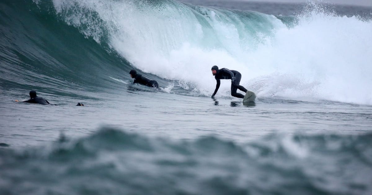
Superior is also one of the few freshwater lakes on the planet that generates ocean-sized surf. Surfing requires water big enough to allow swells to develop, which means winds blowing over hundreds of miles of open water. The topography (bathymetry) of the lake floor must also be conducive to forming waves that peel rather than closing out all at once. Stony Point is a popular surfing destination for the lake, yet surfing there began only two decades ago.

Superior’s frigid waters require that surfers wear the thickest wetsuits possible because the best surfing happens in the coldest months, fall through spring. Rocky shores demand solid skills to avoid injury.

Stoney Point surfers. Startribune.com

Stoney Point is close to Duluth, a medium-sized port town with an accessible airport. However, there is a lot of isolated shoreline in Lake Superior with high potential for surfable waves, yet these are usually so remote and inaccessible they have never been surfed. The problem is exacerbated by the sporadic nature of swells in an inland lake and the fog, high winds, and big seas that often accompany swell-generating weather. To understand these challenges while scouting for solid surf locations, a light expedition was needed.

Ryan Patin preparing to surf Isle Royale’s south shore. Photo by Matthew O’Keefe.

I met two Lake Superior surfers, Ryan Patin and Stefan Ronchetti (we all work for the same software company) who’ve surfed Lake Superior for years, almost since the beginning. They were passionate about finding new surfing locations on the lake, and had already executed several driving trips (light expeditions actually) to surf remote parts of the north shore of Superior in Minnesota. They were excited about the potential for surfing Isle Royale, an island 20 nautical miles offshore in the northern part of Lake Superior. The bathymetry looked very promising in the southeast portion of the island, which was also exposed to hundreds of mile of fetch (stretches of open water over which the wind can blow) from the southeast and southwest.

Matthew O’Keefe and Ryan Patin (left), Windigo, Michigan

Ryan and I traveled to Isle Royale, a national park, in July 2018 to scout potential surf locations. Over the course of three days were able to circle the island in my Zodiac 650 RIB (Rigid Inflatable Boat), mapping and photographing dozens of sites with solid potential. We also practiced getting a surfer in and out of the boat safely, and operating the Zodiac in the shallow reefs where surfable waves happen. Ryan even did a little surfing in a dying swell on our first full day on the island. Since this trip was in the summer, the weather was ideal for testing the logistics and scouting potential sites, but not ideal for surfing, which happens in the colder months.

This light expedition combined my boating and camping experience plus navigation skills, with Ryan’s surfing expertise and talent. Based on this trip, we are considering another trip in October or April timed to coincide with strong surfing potential based on Lake Superior weather forecasts and wave models. We will be able to refine the logistics and safety planning along with focusing on the potential surf sites with the most potential. Perhaps we will be able to find a huge wave where no one else has.

At Beaver Island, Isle Royale National Park.

The links below point to all three essays in this series on light expeditions.

Part 1: The Power of Light Expeditions

Part 2: The Best Skills to Master for Light Expeditions

Part 3: Light Expeditions, Lake Superior Style

The Best Skills to Master for Light Expeditions

Part 2 of 3.

In Part 1 of this 3 part series, I introduced light expeditions, journeys accessible to anyone willing to develop the necessary strength, courage, and mastery. A light expedition is a short, performable (in personal cost, preparation time and duration) journey with a purpose that leverages and develops masculine skills and confidence while building self-understanding. It also affords opportunities to discover secrets and achieve firsts.

What kind of journey’s make you better at being a man from the perspective of Jack Donovan’s male virtues?

Jack Donovan, author of The Way of Men.

And what journeys and skills have good masculine aesthetics and appearance, can be recorded and inspire creative works, and provide the chance to socialize with family, friends, and interesting women?

From my perspective, the pro-masculine skills to master for light expeditions should answer the following questions affirmatively.

(0) Are there low-overhead, low-cost ways of participating almost anywhere? This allows you to practice the skill regularly.

And can you start out with a one-time experience (e.g., bucket list checkoff) and then incrementally grow it to a hobby, from a hobby to proficiency, and from proficiency to mastery?

(1) Does the skill allow practicing to scale, so that practicing on a small scale applies at a large scale as well? Can you experience the skill at both small and large scales?

For example, sailing a dinghy (i.e., a small personal sailboat like the Laser show in this photo) is low-cost and easy to learn; can be done on almost any body of water, large or small; and yet it significantly improves your understanding of winds and waves. Racing dinghy’s also increases your understanding of race tactics for all types of boats and race courses.

(2) Are there upper limits to mastery, and who can reach them? Are there deeply experienced masters of the skill willing to teach you and are they readily available?

Skills to Master for Light Expeditions
Canoeing the Seal River during a forest fire. Photo: Hap Wilson.

(3) Can you get killed doing it if you don’t have a minimum level of mastery? This seriously reinforces the need for strength and courage.

(4) Can you test your courage with the skill by pushing beyond the limits of your current mastery to achieve more mastery, in ways that are prudent and not reckless? By doing so can you accrue honor in some form?

(5) Can the skill take you to remote places that few others get to see regularly? This is key to having unique explorations, and to finding secrets. It also likely means it requires some courage to make the journey there.

Master for Light Expeditions
Outer Island, Lake Superior. Photo by Matthew O’Keefe

(6) Does the skill easily allow you to bring others — friends, family, attractive woman, LTRs, etc. — to see places few others get to see, on explorations that excite the imagination?

(7) Are the aesthics of the skill good and is your expedition worth recording, either in photos, film, paintings or drawings?

(8) Are new technologies continually changing the sport keeping things interesting, requiring more mastery, offering more chances to push your current mastery envelope and the state-of-the-art to gain honor via accomplishing firsts and finding secrets?

What skills emphasize the masculine and male virtues and provide the richest experiences? With these questions in mind, I’ll make my case.

Some Good Skills for Light Expeditions

Sailing: In sailing, more strength and more stamina translates directly to better performance: trimming sails, grinding winches, heaving anchor, and overnight watches all can be performed better with more pure muscular strength and stamina.

Moving heavy boats (or small ones) in big seas requires experience (mastery) and a calm demeanor (courage). As your mastery increases, you can push the envelope on the size of waves and wind your willing to sail in, but new, tougher conditions almost always require increased courage to overcome the sailor’s initial nerves when facing the new situation.

Sailboat Riva completing the Pacific Cup Race, 2010.

New, challenging conditions can happen suddenly (wind gusts, storms, lightning, etc.) and must be faced and mastered. Honor can be won in sailing via achievements in competitive races, either inshore or offshore, and by completing long, difficult voyages against your current level of skill. As your mastery increases, your courage and strength become important as you push the level of difficulty.

Whitewater canoeing and rafting: Strength, courage, and mastery all play a role in successful whitewater canoeing and rafting. Mastery is required to plan properly based on your current skill level across a spectrum of required tasks: logistics, routing, navigation, paddling technique and form, reading and running rapids (or not), lining, packing, camp-craft etc. Depending on the area, you may need to contend with bears (black, polar, or grizzly) or other aggressive wildlife.

Attean Lake, Maine. Photo by Matthew O’Keefe.

Canoeing scales up and down quite well, as experience gained on local waters, even flat water, translates directly to trip expertise. Finding whitewater can be tougher than finding flat water, depending on where you live, but modern air travel and support from canoe and raft outfitters on the best rivers can easily overcome this.

Surfing: Strength, courage and mastery are all critical in surfing, for safety reasons and to be able to push the envelope on the size of waves you can surf. The skill scales up quite well, and the search for the perfect wave or to be the first to surf some remote, beautiful, undiscovered location with huge waves (a form of secret) is intoxicating.

The best Master Skills to for Light Expeditions
Stony Point, Lake Superior. Photo: Surfing Magazine.

In addition, taking family and friends to the beach always gets a positive response, and there is no question surfers are thought of as masculine by many women. Surfing aesthetics are excellent, and it can be practiced with friends and family nearby.

Hunting: Hunting is an ancient sport and one that early men performed in small groups. It requires all 4 masculine virtues, and provides intense socialization with other men. In some cultures, deer hunting is something the whole family does together. It’s rather mysterious but the male bonding the comes from a joint, successful hunt is primordial and seems to tap into something deep in the male soul. Fishing has similar characteristics. Hunting and fishing are also excellent ancillary skills for light expeditions, even if they are not the end purpose of the trip.

Motorcycles: Motorcycles have great masculine aesthetics, are associated with small gangs of men, and are legendary for the variety and depth of the journeys one can achieve with them. Given the dangers to bikers on the open road, it requires and signals a base level of courage to even ride them.

You might think that my emphasis on aesthetics is superfluous, and yet… we are entering a golden age for gifted amateurs to record and artistically express what they have accomplished on light expeditions. Incredibly cheap yet sophisticated digital cameras like GoPro’s, combined with cheap film editing tools like iMovie and Final Cut Pro allow literally anyone to beautifully record their light expedition.

Although this list is not complete, these four skills are excellent for developing masculine traits and performing light expeditions. I hope this essay has you thinking about other potential skills that could be leveraged for light expeditions. The links below point to all three essays in this series on light expeditions.

Part 1: The Power of Light Expeditions

Part 2: The Best Skills to Master for Light Expeditions

Part 3: Light Expeditions, Lake Superior Style