A View of Heaven
What does Heaven really look like? I was about to find out as I pushed my kayak from shore. I needed to cross 6 miles of big water with strong wind blowing to get to a bay my sailor friends had described as “Heaven”. Read on and you can find out if I made it and what heaven really looks like.
In previous posts I’ve described several boat camping trips on Lake Sakakawea and a sea kayak trip down the Missouri River. Here I describe crossing Lake Sakakawea in a sea kayak on an overnight trip. My goals was to connect with sailor friends at a place they told me was Heaven.

The Trip Plan for Lake Sakakawea
I had done a few short day trips in my sea kayak on Lake Sakakawea to help build up more big water experience. Lake Sakakawea stretches 180 miles from the dam near Pick City in central North Dakota to Williston, on the border with Montana. The lake is the second largest reservoir by surface area in the US after Lake Oahe and it averages between 3-4 miles in width. It has 1320 miles of shoreline. That’s longer than California’s coastline. This article in the New York Times provides excellent descriptions of the lake and its shoreline.
My goals this trip were to do my first overnight camping trip in the sea kayak, and do an open water crossing where I wasn’t just hugging the shoreline as I traveled. My reward was a the chance to stay in one of the prettiest bays on the lake while connecting with my good friends who had sailed there ahead of me.
Heading Into the Open Water
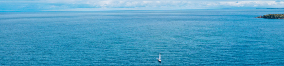
The trip occurred over a weekend in June 2015. I traveled to Indian Hills resort and boat landing on the north side of the lake, about 30 miles due south of Parshall, North Dakota. My destination was on the south shore, roughly 7 miles southeast from the entrance to Good Bear Bay, where Indian Hills resides.
And this is where things got interesting. At this point my sea kayaking experience was very limited. Large waves in open water were new to me. In fact, I had abandoned several previous attempts to connect with the sailors because it involved 8 to 10 miles of sea kayaking over open water against a big wind. But today, as I worked my way out of Good Bear Bay to the big lake, I had decided no matter what, I was going to cross the lake.

On my way to the open lake a peninsula on the edge of the big water was perfect for lunch. The wind to that point had been light, about 5-7 knots, but it was gradually increasing to 12-15 knots from the west. The waves were building to 2 to 3 feet rapidly across a fetch (stretch) of 10+ miles. Should I go, or not?
Decision Time and the Margin of Safety
If the wind continued to increase, the waves would get even bigger. But the forecast was for winds around 15 knots, which I was seeing. Sailors use the Beaufort Scale to gauge wind speed from sea state and conditions ashore. But wind forecasts are often inaccurate, and the wind speed could increase. Going downwind and warm water (meaning I could swim for it for hours if necessary) reduced the risk. If I ended up in the water I would have to get back in and bail out the kayak. My VHF marine radio could be used to contact boaters and the first responder station in Twin Buttes if things went south. A high quality PFD and equipment to get me back in the boat increased the margin for error.

Pushing off from shore and within a few minutes and the kayak was in the larger waves. But the kayak surfed the waves easily. As I headed south-southeast, I quartered on them to enhance stability. My 17-foot Wilderness Systems Tempest 170 sea kayak was stable and comfortable to paddle. There wasn’t much paddling necessary as the waves drove me towards my destination.
The Trip in Open Water
I traveled more south than southeast to get closer to the south shore as quickly as I could. The compass bearing was 110 degrees from my starting point to Heaven Bay, based on my map and the GPS coordinates the sailors had given me. Heaven Bay and that part of Lake Sakakawea’s shoreline were new to me. Often one bay looks like the next one on the big lake.
After about an hour, I had covered four miles and was about 300 yards from the south shore, but further west from Heaven Bay. This is a common practice when navigating: taking a bearing and then deviating to one side or the other as you travel towards your destination. Once you reach shore, you travel in the direction to recover from your deviation, and you can methodically travel looking for your specific destination. This is exactly what I did and it worked perfectly.
Arriving Near the South Shore
The waves had become smaller as I approached the south shore, and fortunately the wind and hence wave sizes didn’t change during the crossing. I had gambled and won.
The only real problem is that I had trouble connecting the features I was seeing on the south shore with the topographical map. I tried haling the sailors on the VHF radio but they were behind several hills and couldn’t hear me. (Always bear in mind VHF marine radios work best when there is direct line-of-sight to the other radio.) One of them climbed the hill, we connected on the radio, and he provided good directions. With my binoculars I could also see a sailboat entering the bay when I was about 3 miles west of the entrance. I navigated towards a landmark on shore (in this case, a distinctive cliff face).
Arrival at Heaven Bay


A large, beautiful, rounded butte guarded the entrance to Heaven Bay. As I turned into the bay, I saw three sailboat masts standing tall and knew I had made it. A few minutes of paddling and here were my sailor friends enjoying the sun and the mid-day heat. It was exhausting and exhilarating, not so much from the few hours of paddling, but more from the adrenaline and stress caused by this being my first big crossing. It was also my first encounter with 3 foot waves in the kayak.
I pulled the kayak up on shore, greeted my friends, then jumped in the water to cool off. After swimming for about 20 minutes, I sat down and did what sailors usually do in port: poured a drink and savored the great company and the beauty of Heaven Bay. I thanked my friends for sharing it with me. After catching up and relaxing for a bit, it was time to get back to work. The gear from my kayak was unloaded. The tent was set up on a small, flat peninsula.

Heaven Bay’s Geography and Geology
Indian Hills and Heaven Bay are in the middle of the lake. Further west the lake turns north towards the huge Van Hook Arm and also south into the Little Missouri arm. It’s ideal for sailing because you can choose the direction you go to optimize your travel based on the wind direction. Heaven Bay is unusual for this portion of the lake in that it is an outcropping of the badlands that dominate the lake shore in the Little Missouri Arm further west. These badlands were formed when ancient volcanoes spewed ash over the swamps that covered North Dakota 65 million years ago. Runoff from ancient mountains added sand and mud. After the buildup stopped, these formations have been slowly eroding to create the badland’s buttes and valleys we see today.

The evening was fantastic, with eagles, vultures, and night hawks entertaining us with their flight and the setting sun painting the tops of the butte in a beautiful soft light.
The Trip Back
The next morning I awoke early to take some golden hour photos. After breakfast and coffee, I said my goodbyes to my friends and headed back across the lake to Indian Hills. There was no wind. The lake was still, a flat calm. After three hours I arrived in Good Bear Bay once again, and traveled up it to the Indian Hills take out.
New Indian Friends
While packing up for the drive back home, I met two young Indian men. The Fort Berthold Indian Reservation contains the middle section of Lake Sakakawea where I was traveling. Most of the locals are Native Americans.
While taking my kayak out at Indian Hills boat ramp none of the other boaters were very friendly. This is expected. Fishermen just want to get their boats in or out of the water and get going.
However, the two Indians from Mandaree asked me if I fished from my kayak and said they really liked my boat. I told them the eskimos did use the original kayaks for hunting, and modern sea kayaks were just pale imitations of the original sea kayaks the Indian’s made. The Indians told me how they use their kayaks for fishing. We had a good chat and then shook hands and parted. I need to figure out how to connect more with my new Indian brothers the next time I’m out sea kayaking on the reservation.

Observations

Margin For Safety
It could be argued that it was too risky to make this crossing the first day. In fact, many sailors who ply the lake were concerned as they had seen the lake at its worst. As I mentioned, the sea kayak was much more stable in the 2-3 foot waves (and occasional 4 footer) than I expected. I’m not sure what it’s rated for, but I think I could handle up to 5 foot waves if I can quarter on them and the waves are mostly regular. More experienced sea kayakers are welcome to provide their thoughts in the comments.
Gear Improvements
One thing I changed after this trip is the system I used to tie gear down on the deck. There was too much gear not properly tied down and just hanging from my neck, and if the kayak had flipped, it would have been painful getting it all back in place.
For longer trips over open water, a compass on the deck above the bow is a necessity. It’s almost impossible to both paddle and look at the compass often enough to stay on track.
Privacy and Ease of Camping
Two other things struck me about this trip. First I was surprised how easy it is to camp on Lake Sakakawea. There are beaches and flat prairie everywhere, lots of dry driftwood for fires, easy access to water, and privacy. It turns out that fishing boats and power boats are often reluctant to cross the lake, and Heaven Bay is quite far from any boat ramps on that portion of the south shore of the lake. So except for the occasional sailboats, it’s a private place.

Prints of the Photographs
If you would like to get prints of any of these photographs, you can do so by going to this web site.